Monday, August 16, 2010

More Aug 14 pics


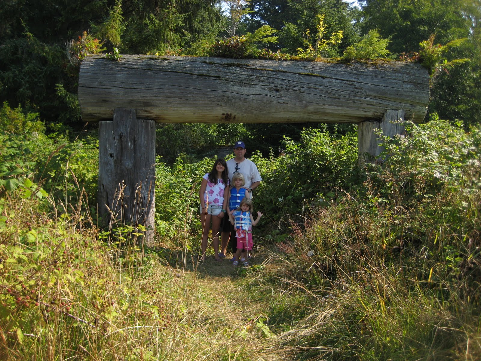
A few more from the abandoned Native village, specifically the dock and beach. The white sand is clamshell eroding away from the 15ft high bank that was built up over the centuries of clamshell campfires.

This is one of the villages that Capi visited with her kids in the boook The Curve of Time, and is one of the last villages to be occupied. Apparently the ceremonial Potlatch was outlawed at some point, and the last one was done here illegally at some point with many arrests. Most of the Natives decended from this village now live on Vancouver Island in Alert Bay or Port Hardy.

Aug 14


Today, brought clear conditions at first light.. no fog a sign that the high pressure is camped over us and here to stay!!!! We had a leisurely breakfast, did some reading, then piled into Tooth Ferry for a ride to Mamalillicula to see if anything was remaining. We hit it at low tide so finding a spot to get ashore was tough, but finally we found a spot on a piece of the decrepit abandoned pier. A decent trail through the woods brought us to the overgrown village. The first building was probably the schoolhouse we heard was built in the 1930's and was a well built impressive structure. Ahead through the salmonberries we could see fruit trees that lined the overgrown village and an abandoned house. We walked a trail to the beach, slid down the midden, and walked the white clamshells to the opposite end of the beach. Along the high bank there were areas you could see the midden in good detail, layer upon layer of clamshells and campfire ashes. Standing at the mid-point of the beach thinking about the Natives throwing their clamshells into the campfire, night after night, century after century, long enough to make a midden 15 feet high and a half mile long... wow. We found a trail was cut through the overgrown salmonberries through the orchard and to the abandoned house and what we have read were some totems and logs associated with the village longhouse. The blackberry vine cuts and mosquito bites were well worth the experience, memories and photos. Back to Mental Floss for bratwurst lunch and working on the puzzle while Dad Went fishing in the dingy (with no luck).

August 13


On Friday the 13th, Mental Floss was underway at 0545 and ran Johnstone Strait in 2.5 hours all the way to Blackfish Sound. Wind was recorded as 2kts and I'm sure Brad Alvord could have waterskiied the entire 40 miles! Good decison confirmed. We now had several discussions about what to do, since the weather had so much influence on our potential itinerary and now is forecasted to be flat calm and hot for five straight days we can pretty much do whatever we want... so many possibilites it is difficult to choose!!! We decided to start salmon fishing and think about it. We relaxed and trolled from Parson Bay to Swanson Island past Flower Islet. Maren caught a small pink and at 3pm Daddy caught a 22lb king! We ducked into the Village Group of islands and anchored in a small bay on Crease Island called Goat Islet Anchorage. Two other boats gave us plenty of room as we vacuum packed salmon (all but one piece). The Village group is named for the First Nations people who occupied this area for centuries. From our spot we can see the beach at Mamaliliculla about 3 miles away, the site of a village that was repopulated in the 1930's and then eventually abandoned. A dinghy ride there tomorrow probably.

August 12


On August 12 we slept in, took showers and filled the water tanks again at Blind Channel Resort. The weather reports were very consistent at gale force winds gradually diminshing all day in Johnstone Strait and a decent forecast for Saturday (they have been very coy about Friday) so we all agreed that a slow trip to Forward Harbor, the last safe place before Johnstone, would be the best plan. After a great breakfast we headed out and followed the end of the ebb at 7kts (plus a 3 knot push to 10kts) out Cordero Channel to Welbourne Channel and Whirpool rapids at slack tide to Forward Harbor. Anchoring in Douglas Bay we zipped our crab pots out and did some kelp bed fishing so if we get the hankering for rockfish tacos.... No big ling cod yet. Then we took what should have been a short hike through the woods across the isthmus to Bessborough Bay. However, I left the initial routefinding to the 13 and below crowd and soon we were at an impasse and had to turn back to the beach. Once there I noticed a much more established trailhead and we had no trouble and made the easy roundtrip back to full crab pots!

Thursday, August 12, 2010

A few more


Here are a few more photos from yesterday... weather still looking too windy to proceed N until tomorrow. Should be a relaxing day today. RC

Wednesday, August 11, 2010

Blind Channel Resort


Aug 11, 2010
9:30pm

Great trip so far!
We left Gig Harbor on Sunday after spending the weekend attending Amie's 20 year reunion. At 12:30 we put the boat in gear and cleared Customs via phone since we have the NEXUS card. This allowed us to bypass docking and reporting, and with a favorable weather report we zoomed 2.5 hours right up the Strait of Georgia to Welcome Pass and tucked into Garden Bay in Pender Harbour. With more favorable weather we got an early start on Monday and stopped in Lund to provision. Our plan to meet the Alvords, Ericksons and Osterlohs in Pendrell Sound worked great and we all arrived within an hour of each other. Pendrell Sound is positioned so that the water flows equally north and south around Vancouver Island so it gets very little flushing and is 68 degrees warm. There's a picture I'll try to send of Amie and Addie on the bow with snow covered peaks 5000 feet straight up, and 1500 feet deep, you'd never believe the water was so warm.

Our friends all had kids and cousins and Steve put a full day's time running them on innertubes and waterskis around the sound. Addie even got into the act with Jessie Alvord on our tube getting towed by Dad in the Tooth Ferry. Prawning was poor, relaxing was excellent!

In the interest of fishing and spending more time at sites we barely touched last year we left our friends in Pendrell and ran Yulculta, Gillard and Dent rapids to Cordero Channel and Blind Channel Lodge. We are currently tied to a dock here with UNLIMITED WATER! so we all showered the salt off and gave Mental Floss and Tooth Ferry II a good bath. Maren, Lauren and I hit a few kelp beds and came away with a few dusty rockfish, but we all know this battle has just begun...

Just before dinner we took a half hour stroll to the biggest cedar tree imaginable! In fact there are several in a grove not far from the dock, somehow spared the in logging that happened here in 1885 and 1988. The photos don't do these trees justice, the scale is impossible to record without being there. Reports are from 7-800 years old to 1500 years old, I'm certain nobody really knows.

The wind has been howling up north so we're going to delay our ideal plan one more day. By Friday things should smooth out to the point we can be comfortable. Plus it gives us a day to sleep in and explore this area some more. We will leave our dock and the UNLIMITED WATER! and head toward Johnstone Strait, but I really think we will be turned back by the NW wind against the Ebb tide, so will probably anchor in Forward Harbor and wait for Friday's lower winds. Friday will be an early start and our Friday night plan will be determined by how nice Mr. Johnstone is to us and which route we need to pick to get to the Broughton Islands.

Kids are well fed and exhausted from all the water sports and fishing.

Next e-mail report will probably be Sunday or Monday.

:)

RC

Wednesday, August 4, 2010

Real Time GPS

We plan on leaving around noon this coming Sunday, 8/8 to head north.
If you are curious you can track our progress at this website:

http://share.findmespot.com/shared/faces/viewspots.jsp?glId=0uhAUb5Tzvc67K9lTopj92gzZblmHADWn

A few things:
1) the GPS works flawlessly, the website notsomuch. If there is no data check back later (it doesn't mean we've sunk)
2) Googlemaps looks best in "hybrid" mode
3) Only the past 7 days of data will be shown.
4) I'll turn the unit off when we are anchored.
5) It uploads in ten minute increments.

RC